
Pelaw Wood is located east of Durham City on the eastern bank of the River Wear between Gilesgate and Old Durham. The land rises steeply initially, from about 40 m above Ordnance Datum alongside the river to 85 m above Ordnance Datum as it levels off in the east. Pelaw Wood Beck flows east to west in a steep sided valley forming the northern boundary of the wood.
The oldest sediments exposed around Durham are the Middle Coal Measure strata of Carboniferous age – dating from about 300 million years ago. Thirty-five foot thick Main Post sandstone above the Low Main seam forms the bedrock beneath much of Pelaw Wood. Durham Cathedral is built on the same sandstone. Abandoned mine workings are present in the 0.7 m thick Low Main seam beneath the eastern extremity of Pelaw Wood Beck. The eastern part of Pelaw Wood in general is also undermined in the Hutton seam, and these workings extend south to Old Durham where they are at a depth of 40 m. This seam, some 1.7 m thick and 28 m below the Low Main seam, was last worked from Old Durham Colliery in 1896. Coal seams of the Middle coal measures can be seen at surface around Prebends Bridge and Kepier Woods in Durham.
A large period of geology time is not represented beneath Pelaw woods. The Aeolian (wind-blown) desert Basal Permian sands and the Permian-Triassic magnesium limestone can be found east of Durham in the hills around Sherburn and Pittington. Around the Centre of Durham however all sediments deposited above the carboniferous were removed by erosions until the Pleistocene.
During the Pleistocene epoch – part of the Quaternary Period – that started about 1.8 million years ago and lasted until about 10,000 years ago, Northern Britain was affected by major climatic cycles of glaciations with temperate alternations. Probably during the most recent major glaciation a deep channel or valley immediately west of the wood was eroded that runs north to south – roughly along a line from Shincliffe Bridge to the Gilesgate roundabout, continuing northwards – with its base at about present day sea-level. Pelaw Wood lies on the eastern side of this valley that is now buried with glacial drift. The ice-sheet became stagnant and melted rapidly releasing large quantities of meltwater that deposited sands and gravels within the channel. Meltwater streams flowing under the melting ice also contributed to the erosion of the channel and the deposition of some of this material in the form of Eskers. These glacial drift deposits comprising gravelly sands and sandy gravels are exposed along the steep sided bank close to the River Wear in Pelaw Wood and also along the southern bank of Pelaw Wood Beck.
The glacial sand and gravel is overlain by till or stony clay and this is preserved on the higher ground in the east of the wood.
Finer grained material was deposited with increasing distance from the wasting lobes of ice and this resulted in an accumulation of laminated clay that extends northwards through the City and is present in the extreme west of Pelaw Wood at the footbridge over the beck. Laminated clay is weak and can fail where present on slopes especially when water logged. resulting in landslips.
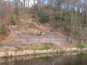
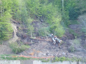 A substantial landslip is evident between the River Wear and St Bede and St Hild College. And in 2013 a major landslip in the Wood severed the riverside and terraced footpaths.
A detailed geophysical report has been prepared for the County’s officers and work is underway to stabilise the slip and reinstate the riverside path. The scheduled completion date for this work is March 2016.
Recent River Wear and Old Durham Beck alluvium forms the lower lying level ground in the south of the wood to the north of Old Durham, where former higher river terraces are also present.
[Revised 21 August 14]