
A ridge with ground falling away both sides more steeply to the South but flattening into an open grassed area.
Mixed open grassy area with low trees and shrubs on south facing slope, east/west running ridge with more heavily wooded steeper flattening out into open grassy area on the northern side.
 Opening out from the South end of the Silver Link bridge, it encompasses the main way in to the wood from the North side. The smaller North facing slope up to the ridge is criss-crossed by several paths, some quite slippery, leading both East and West eventually out of the woods both ends, and also down the South slope of the ridge to enter into the main woodland. One main site in the lightly wooded area at the edge of the grassed clearing is used by presumably young people for drinking parties as evidenced by the large numbers of lager cans and bottles always present. There is also evidence of fires and lately, trees damaged by saws to provide more fuel for the fires. The open areas are significantly reduced in high summer by massed growth of willow herb, Himalayan balsam and umbellifers. At the Eastern edge of the glades, the wood becomes an area of undergrowth , difficult to penetrate, with many brambles and low trees. There is no clear path into the wood from Rabbit banks except right at the top where it opens onto the common land above Rabbit banks, but it is possible to enter at various places and there is one area widely used for drinking parties with again extensive evidence of fires and burnt out trailers and supermarket trolleys.
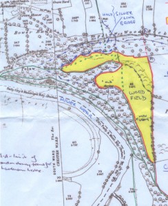 This area was the ‘wood field’ surrounded by an ancient embankment, external ditch and topped by hawthorns that had been laid to create a hedge. See the History page.
The flattened grassed area is the main recreational area in the middle of the wood with an open and pleasant aspect. The North edge of the Glades forms the continuation of the main footpath up from the river bank to the silverlink bridge and provides an alternative pedestrian route from the “Elvet” side of the city to Gilesgate which does not involve any roads.
There is evidence of ridge and furrow in the open grassed areas.
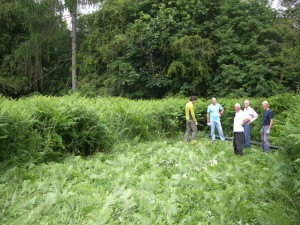
The problems mentioned in the original survey of poor paths and access, particularly in wet weather, have largely been resolved by building steps and hardening path surfaces. The two glades are now virtually free of himalayan balsam and bracken is retreating in the face of annual crushing – as seen in the photo above. But paths are rapidly deteriorating with additional usage by walker and cyclist bypassing the landslide; and there continues to be a need to reduce the encroachment of invasive plants, particularly himalayan balsam.
Ongoing litter clearing and prevention program: possibly by placing litter bins at known heavy litter areas with rota for emptying to council skip at north end of silver link bridge; or a protected planting of thorn shrub (gorse/rosa rugosa) barrier with narrow opening at top of rabbit banks to prevent access to woods for supermarket trolleys and trailers
Active provision of site for recreational use in area currently used for destructive fires and drinking sessions with BBQs, rough seating (logs) & selective tree clearance. This is based on premise that enjoyment of the wood should be inclusive and not exclusive, and that as it will be almost impossible to prevent drinking sessions in the wood, better to try to “legalise” and thus have more control than stamp it out altogether.
Resurveyed by Elly Greenway and Jess Hodgson on 7th June 2015:
Also present: nipplewort, sorrel, burdock, hogweed, herb Robert, white clover, ribwort plantain, creeping thistle, white campion, bracken.
Orange tip butterfly.